Historical News
Nomination of “Creswick Goldfield Water Distribution Heritage Precinct”
- for the State Heritage Register
The high density and intactness of numerous 1850-80s water races and dam sites is a well know feature of the Creswick alluvial goldfield southeast of Creswick. The La Trobe University’s ‘Rivers of Gold’ project helped to document historical details of this valuable water distribution system, so was vital to miners and the development of the goldfield and the extraction of gold from 1853 until the 1920s.
Over the past few years, members of the C&DHS have encouraged efforts by a group of Ballarat and Creswick individuals and groups to prepare a research document as the basis for the nomination of the above Heritage Precinct to the State Heritage Register. This nomination was submitted to Heritage Victoria in March 2024, and has been support by various Historical Organisations. Main features of the proposal are:
- The Precinct covers an area of 27.3 sq km of crown land southeast of Creswick.
- The land is in State Forest (13 sq km), Creswick Regional Park (12 sq km) and Central Highlands Water catchment (2.3 sq km).
- Most of the Precinct lies in Hepburn Shire, with nearly 20% in the City of Ballarat.
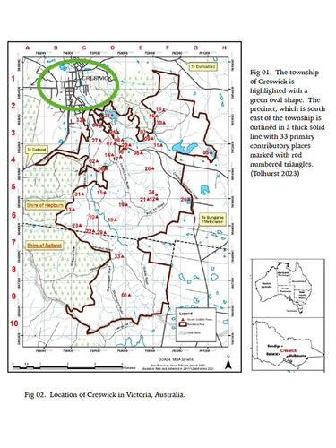
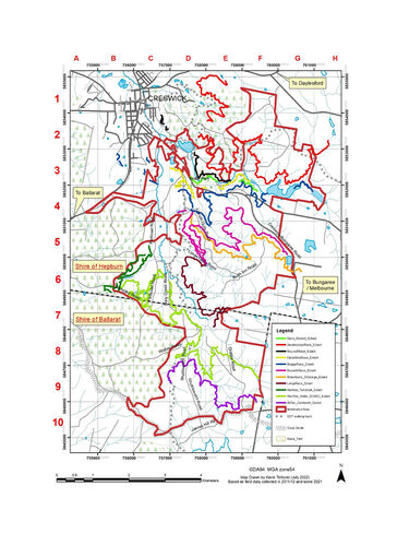
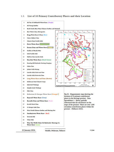
- The Precinct includes 33 historical places, including 11 main water races (over 100 km), many dams, Chinese gardens and Gold Puddling sites – all from the 1850s-90s gold rush.
The 33 historic places are shown on outline maps below, and described in detailed mapping and 180 photos and 50 maps submitted with the 300 page research document “Creswick Goldfield Water Distribution Heritage Precinct“ (Huddle Petheram and Tolhurst 2024).
The main significant heritage aspects of this Precinct are the density and intactness of the water races, the international entrepreneurs who built and operated these water supplies, and the involvement of Chinese miners and entrepreneurs in managing water. Also significant is the way the development of early water-enterprises helped to change the water law in Victoria and later Australia.
Special credit goes to Lorraine Huddle (Heritage Professional) for her voluntary work in combining the results of research by ‘La Trobe University’s ‘River of Gold’ Project’, with recent photos, historic maps and images, and for making a strong case for State Heritage Significance for the Precinct. The mapping, local knowledge and field surveys of Dr Kevin Tolhurst from Creswick and the University of Melbourne Campus was invaluable to the Nomination, as were the contributions by local historians David and Don Henderson and Jack Van Beveren.
The 3 maps below are taken from the project Document:
Download Map 1: 1st map shows Creswick, Precinct boundary with 33 historic places, Great Divide and main roads.
Download Map 2: 2nd map shows the Precinct boundary and the location of 11 main water races and main dams
Download Map 3: The 3rd map lists the 33 historic places and shows their numbered locations in the proposed Precinct
Learn More About our Society
- Family History
- Creswick & District
- Migration
- Honour Roll
- Membership
Contact Creswick and District Historical Society today. We would love to hear from you!


